![]()
![]()
![]()
It is our mission to provide Quality Services that ensure the Integrity of Surveyed Real Rights and to supply, maintain and provide access to Spatially Related Information for the People of our Country.
|
It is our mission to provide Quality Services that ensure the Integrity of Surveyed Real Rights and to supply, maintain and provide access to Spatially Related Information for the People of our Country. |
Projects | CIS Projects | Spatial Data
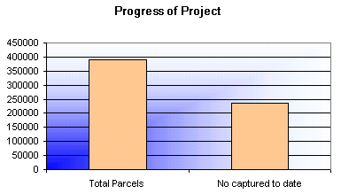
This project was initiated to capture the post-1997 approved spatial land parcels in the following four provinces: Gauteng, North West, Northern Province and Mpumalanga. This project commenced on the week-ending the 18th of March 2000. The project is expected to be completed at the end of October 2000.
There are an estimated 389 480 parcels which need to be captured. The data is captured in ReGIS and saved as drawings. The data is quality controlled by experienced Surveyor General staff after the capture process for a particular area has been completed. The data that is currently being captured is co-ordinate accurate and will provide the basis for the cleaning up of the spatial data. This data will be incorporated in the continuous geographic database when Project Cleansweep starts.
The project team is made up as follows:
| 1 x Project Leader | - | Computer Foundation staff member |
| 1 x GIS Analyst | - | Computer Foundation staff member |
| 1 x Operator | - | Computer Foundation staff member |
| 3 x Survey Officers | - | Pretoria Surveyor-General staff members |
| 2 x Quality Controllers | - | Pretoria Surveyor-General staff members |