![]()
![]()
![]()
It is our mission to provide Quality Services that ensure the Integrity of Surveyed Real Rights and to supply, maintain and provide access to Spatially Related Information for the People of our Country.
|
It is our mission to provide Quality Services that ensure the Integrity of Surveyed Real Rights and to supply, maintain and provide access to Spatially Related Information for the People of our Country. |
Project Broom was identified as one of the projects most important as its product will provide intelligence to the Cadastral Information System. This project entailed the capturing of historical data - alphanumeric information - about land parcels such as their erf number, region name, parentage, etc.
In May 1999, after the completion of nationwide pilot projects, project Broom commenced in the offices of the Surveyor General in Pretoria, Cape Town, Bloemfontein and Pietermaritzburg. The aim of this project was to capture all alphanumeric information contained on diagrams and general plans approved prior to 1997 in a Microsoft Access database. This data included document references, designations, extents, servitudes, leases, deeds references, endorsements on these documents, survey records, parentage, etc.
The Microsoft Access Database serves as an intermediate database, the data will be imported into the CIS Oracle Database, where it will be used extensively in the automated Quality Control and cleanup of the Miracle Spatial Data.
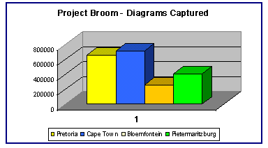
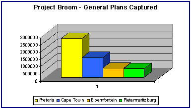
The table below indicates the number of land parcels for diagrams and general plans, per office, that were captured in Project Broom.
| Diagrams | General Plans | |
| Pietermaritzburg | 334 208 | 455 321 |
| Pretoria | 700 000 | 2 750 000 |
| Bloemfontein | 283 225 | 587 795 |
| Cape Town | 750 000 | 1 600 000 |
| TOTAL | 2 067 433 | 5 393 116 |
The results of the tests conducted during the pilot projects indicated that an average of 33 diagrams, per hour per person, and 315 land parcels for a general plan, per hour per person, respectively, could be captured. Using these calculations the original date of completion for this project was the 31st of March 2000.
However, the actual capturing rate during the project was slightly lower than the pilot project averages, mostly due to the amount of information being captured. Also some very old documents [1700 and 1800's] required substantial changes to the software and has sometimes slowed down the production rate.
This project to capture over 2 million diagrams and 36,000 general plans ended on the 31st of July 2000 and was done by contractors, supplied by our consultants - Ariel Technologies.
The contractors used in this project were fully representative with an emphasis on previously disadvantaged individuals. Special attention was given to transfer computer skills and a basic understanding of cadastral documents to all those who worked on this project. Project Broom was completed within 15 months.
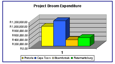
The graphs below shows the approximate expenditure on Project Broom and indicates the total number of Diagrams and General Plans captured by each office during the course of the 15 months of the project.