![]()
![]()
![]()
It is our mission to provide Quality Services that ensure the Integrity of Surveyed Real Rights and to supply, maintain and provide access to Spatially Related Information for the People of our Country.
|
It is our mission to provide Quality Services that ensure the Integrity of Surveyed Real Rights and to supply, maintain and provide access to Spatially Related Information for the People of our Country. |
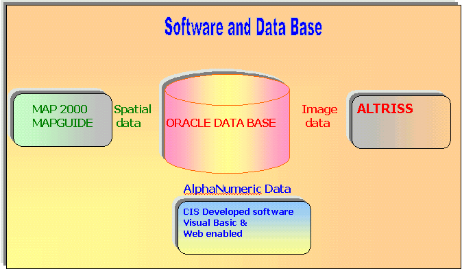
Oracle Version 8.04 and Oracle 8i is the standard Relational Database Management System used in the Surveyor Generals offices. All image and alphanumeric data is stored in the Oracle 8.04 database. The spatial information is stored in Oracle 8i.
The spatial data is managed using the Autodesk range of products. AutoCAD Map is used for the manipulation of spatial data and Autodesk World is used for the distributing of this spatial information to internal clients and external clients. To view the spatial data go to the DATA page.
The image data is managed by Altriss. This is a document imaging system which has a scanning component and an image viewing component.
The alphanumeric information is stored in Oracle 8.04 and all programs which access Oracle are written in Microsoft Visual Basic Version 6.